Sunday, December 23, 2007

Merry Christmas

Merry Christmas
Happy and Healthy 2008


Thursday, December 20, 2007

'Yauna Takabara' , the Persian name of the Macedonians


Most commentators have concentrated on the status of communities named in Persian sources and little attention has been given to the nature of the terms used. The sequence of names is not regular at first, with what seem to be ad hoc epithets, consistent with the naming of recent acquisitions; subsequently more formal designations followed. The earlier documents contain references to various peoples living by or beyond a sea. The Apadana Foundation inscription (DPe) mentions Ionians(Yauna) of the mainland, Ionians-by-the-sea, and unspecified countries by and beyond the sea, while some inscriptions of Dareios at Susa (DSm, DSe) refer on the one hand to men of Skudra and petasos-wearing Yuana , on the other Skudra and Yauna across the sea.On the tomb of Dareios at Naksh-i-Rustem 'Skythians beyond the sea' and 'petasos-wearing Yuana' replaced the unspecified 'countries beyond the sea' of DPe. Skythians (Saka) appear in two separate groups.

The Saka Haumavarga (Hauma-drinking Skythians) and Saka Tigraxauda (Saka who wear the pointed hat) usually appear on the monuments between the east Iranian and Indian groups of peoples. A third group of Skythians, Saka Paradraya (beyond the sea), are named alongside Skudra and petasos-wearing Ionians beginning with Dareios' tomb inscription. In later official texts the eastern Saka continued to be listed in the usual place, but the western Saka disappeared. Thus there is no reference to them on Xerxes' 'Daiva' inscription (XPh), although 'Skudra' appear as a separate entry on the two Susa texts, on Dareios' tomb, in the 'Daiva' document, and among the throne-bearers on later royal tomb reliefs. The documents from Dareios' reign must antedate 486 BC and recent attempts to give more precision to their chronology would suggest that the sequence began no earlier than the 490s. Archaeological evidence indicates that there was very little settled occupation of the open steppe before the fifth century BC. This pattern seems to have changed quite rapidly over the course of the following century, although such settlement as there was continued to be scattered. Dareios' greatest problems are more likely to have stemmed from supplying his troops than from harrying at the hands of small, mobile bands. In this respect the campaign against the European Saka did present additional and far more intractable difficulties than those he would have faced in central Asia.

The later texts (DNa, XPh), seem to represent a coherent sequence: Ionians of the Asiatic mainland, followed by coastal Ionians,Yauna Takabara, , in other words, east Greeks, Hellespontine Greeks, north Aegean Greeks, and Skudra as Thracians .

Yauna Takabara seem in some cases, as at Susa, to correspond with earlier designations of coastal Ionians (Paradraya) and have conventionally been taken to mean Macedonians, because of the distinctive flat hats depicted on coins from the Macedonian region. But this is a misnomer. Coins pre-dating regal Macedonian issues which show large hats are difficult to locate geographically and are even harder to identify according to ethnic origin. They are neither strictly 'Thracian' nor 'Macedonian', because at the beginning of the fifth century these terms lacked definition. The Argead dynasty was just beginning to extend control over areas beyond the Thermaic Gulf. Even in the later fifth century, tribal designations are encountered more often than topographic names (Thuk. 2. 99).

If Yuana Takabara were considered by the Persians to correspond specifically to Macedonians, this should be taken to mean their diplomatic partners from 511 BC onwards, the Argeads, and Argead dependencies. Only in 492 did this relationship change from one of loose alliance, albeit on unequal terms, to one of close dependency (Hdt. 6. 44. 1). The Persian documents do not elaborate such niceties. Allies and subjects are listed in the same way, only the nomenclature changes. Thus at the time of DPe, no distinction is made amongst the inhabitants 'beyond the sea'. Thereafter Yauna Takabara is separated out and 'Skudra' likewise.

'Skudra' is the most elusive term. Although Xerxes' 'Daiva' inscription at Persepolis corresponds in other respects with Herodotos' muster roll at Doriskos (7. 61 ff.), the Greek historian has no equivalent for 'Skudra'. Xerxes did proceed to call up troops from amongst the native and Greek settlers along the coast as his army advanced westwards, and the term has most often be taken to apply to Thracians, or Thracians and Macedonians. The etymology of the word is obscure but suggests that the Persians may have used it in a more specialized way than simply to describe their dependencies in Europe as such. The Persepolis Fortification Tablets have numerous references to workers from Skudra and the most obvious candidates for Europeans working in some numbers deep within the Persian empire are the Paionians whom Herodotos makes so much of in his narrative (5. 1. 12-16, 98).

Why did Herodotos make so much of the Paionians?

Herodotos tells us that Megabazos was instructed, after Dareios' return from Skythia, to conquer the whole of Thrace, to bring every city and every people under Persian control (5. 2. 2). Later he seems to indicate that this was indeed carried out (6. 44. 1: 'all tribes on this side of the Makedones had already been made subject to him'). But tantalizingly, the historian tells us absolutely nothing about the campaign, except that Megabazos began by subduing Perinthos and every other city. A few paragraphs later he modifies this statement, intimating that it was the coastal parts of the wider region he was describing (tes chores tautes . . . ta parathalassia) which Megabazos was systematically bringing under his command (5. 10). It seems unwise to take any one of Herodotos' statements too literally.

Cambridge Ancient History Vol 4 mention

The existence of a satrapy in Europe, called 'Skudra', is known from Persian inscriptions (B44, 58f), 'Lands beyond the sea', that is beyond the waters of Asia Minor from the Persian point of view, were recorded in an inscription on the terrace-wall of Persepolis c. 513 B.C and a satrapy 'Skudra' was mentioned in a egyptian record of c.498-7 B.C and then on a list on Darius' tomb at Naqsh-i Rustam, c.486. The name 'Skudra' was probably Phrygian for the homeland, later called Thrace, which the Phrygians had left in migrating to Asia. The peoples of the satrapy were named c.492 B.C as three: 'Saka Paradraya', meaning 'Sacae (a general name for Scythian-type people) beyong the sea', probably the Getae, who resembled the Scythians in customsand equipment; the 'skudra' themselves, mainly Thracians; and 'Yauna Takabara' or Ionians [Viz. Greeks] with a shield-like hat' The last were mentioned also on glazed bricks at the palace at Susa. Some scholars have supposed that the Sacae 'beyond the sea' were Scythian peoples of the Crimea whom Darius had subjugated, but it seems improbable that Persia did hild that area, and that if she id it was assigned to 'Skudra' rather than to the territories in Georgia, centred on Tbilisi. Envoys from 'Skudra' bringing tribute carried two javelins, a long knife and a small round shield, which were characteristic of Thracian troops later (See Pls. Vol., p1,.40 XIX.

The Greek-speaking people with the shield-like hat were the Macedones, renowned for wearing the sun-hat, as Alexander I did on his fine coins from 478 B.C (look the picture). The Greek-speaking citizens of the colonial city states on the seaboard were not mentioned; nor did they wear a sun-hat.

sources:

  1. Ancient Cambringe History, Vol 2, Greek Edition, 2005
  2. Ancient Cambringe History, Vol 4, 2003
  3. The Odrysian kingdom of Thrace, Archbald, Oxford University,1998

Saturday, December 15, 2007

Upper Macedonia, Eordaia

General Information:
Thucydides passage (II, 100) referring to the expulsion of the Eordaioi from Eordaia constitutes one of the earlier mentions of the name of this region. Unfortunately, the mythological evidence for this district remains almost non-existent.

As regards its name, the only safe suggestion is that it was named after the local tribe of Eordaioi.

In Strabo's description (VII, 323) of the route (from west to the east) of the Via Egnatia, Eordaia appeared before Edessa, therefore, it is assumed that Eordaia lay to the west of Emathia Mountain Bermion formed the eastern boundary as far as the plateau of Edessa that served as the northeastern border. A branch of Bermion was also the southern frontier. Finally, Mts. Vitsi and Boras designated the western and northern boundaries respectively.

As regards the pre-Macedonian ethnography of this area, Professors Maria Girtsi and Nicholas Hammond suggested that in the pre Macedonian period Pelasgoi, Paiones (a theory that coincides with Pliny's mention (IV, 10) that some Paiones lived once in Eordaia), Phryges (a theory that was combined with Herodotus'testimony (VIII, 138) that Midas' kingdom stretched around the foothills of Bermion), Illyrians etc. occupied for sometime some parts of Eordaia. However, among those tribes -that constituted in several periods minorities- there was a dominant local tribe, the Eordaioi (Thucydides II, 99).

Unfortunately, as regards their origin, there is no secure evidence, apart from some unreliable suggestions (e.g. Pelasgian or Paionian or Illyrian descent), that were not based on conclusive information.

Nevertheless, Macedonians according to Thucydides (II, 99) killed the majority of Eordaioi and forced the others to migrate to Physka. Those violent acts of the Macedones were justifiable by the fact that Eordaia was about to constitute the western frontier with the other U.M. districts and Illyria, and thus any danger of internal revolt (by the locals) had to be avoided.

As regards the date of the annexation of Eordaia, that served as the starting point in the Macedonian history of this district, although there is no exact evidence, Alexander's I reign served as a «terminus ante quem» (Thucydides II, 99). Moreover, Eordaia was affected (either as a separate area, or as an already incorporated part of Macedonia) by the Persian presence, since Eordaioi were included in Xerxes' army troops (Herodotus VII, 185).

Sites :
In Eordaia belonged at least the below mentioned sites: Arnissa, Kellai, Bokeria, Galadrai, Kranna, and Greia . Moreover, a list of unidentified archeological sites.

ARNISSA
Thucydides (IV, 128) testified that Arnissa was the first site (to the west) of the Macedonian Kingdom -in the time of Perdikkas II. Therefore, according to our knowledge that the western district at this era was Eordaia, Arnissa should belong to it. Consequently, Ptolemy's (III, 13.20) mention of an Arnissa as a site of Taulantioi either concerned another homonymous site or constituted an error. Moreover, Leake placed it in the vale of Ostrovo, while Samsares located it near modern Arnissa (ex. Ostrovo) where some ancient remains have been come to light. Hammond on the other hand, relying on Thucydides' passage, placed it in modern Petres, which seems more plausible as the site of Kellai (as will be evident below). Evidently, there is still a lot more to be done, so as to secure the location and define the status of the site.

KELLAI
Hierocles («Synecdeme», 638.11) included in his account of the stations of the Via Egnatia, a site called «Kellai», the additional information by the Antonine itinerary, (319-320 and 330.3-7 ) Itinerary Burdigalense (605-606) that Kellai lay between Herakleia and Edessa, at a distance of 40metres and 30metres respectively, led to its location in the district of Eordaia. There are several suggestions like Demetsas as regards its exact location (e.g. modern Arnissa, modern Amyndaion etc.), however the most plausible one is that it was situated on modern Petres, a site that coincides with the distances given by the Itineraries. Moreover, at mound Gradista (500m northwest of Petres) has been discovered an ancient site, organised in terraces.

BOKERIA

A milestone of a 4th-3rd century BC road, mentioning «from Bokeria 100 stadia», found recently in modern Kirli Derven, led to the assumption that a site called Bokeria could belong to Eordaia. Desdevises-du-Dezert Demetsas on the other hand, had earlier claimed that a site called Begora -being named after the lake Begoritis or vice versa- should have existed, although it was not mentioned by any ancient writer.

GALADRAI
Lycophron (1342, 1444 ) mentioned that a Galadrai belonged to Eordaia, while Stephanos Byzantius identified it as a Pierian site. The lexicographer placed it at the south extremity of Eordaia; however, the controversy of the ancient sources, along with the lack of any other evidence, prevents any further discussion.

KRANNA
Professor Maria Girtsi state in his book that a Roman inscription (SEG 1, p.65.no.292) mentioning a man from Kranna of Eordaia, implied the existence of such a site, at least in the Roman era. The lack of any other evidence prevents any suggestion for its location or any further assumption.

GREIA
Professor Maria Girtsi state in his book that a Hellenistic inscription found in the vicinity of Eordaia,(kanatsoulis p.2] )and referring to the site of Greia, attested the existence of such a site, at least in the late Hellenistic era. However, the lack of any supportive information does not allow the secure identification of its location or any further comment.

UNIDENTIFIED SITES
In Florina, Agios Panteleimon, Amyntaio, Kastro, Ammochorion, Beuve, Ano Kleinai, Palaistra and Kato Kleinai have find traces of late Classical-Hellenistic habitation architectural remains, houses, roads, pottery sherds, figurines and coins .

Sources

  • Demitsas M, Ancient Geography of Macedonia,1879
  • Nicholas Hammond, History of Macedonia Vol 1, 1972, Greek edition (1996)
  • Sakellariou, Macedonia: 4000 Years of Greek History, 1982
  • Nikolaos Martis, the Falsification of Macedonian History, 1984
  • Eugene Borza, the Shadow of Olympus,1993
  • Maria Girtzi, Historical topography of ancient Macedonia,2001

Friday, December 14, 2007

Philip II and Alexander III Wives


PHILIP II
Audata
Philip married her when they were both 20years old. She came from Illyria and gave him a daughter, Kynna.
Phila
She was sister of Lerdas and Machatas.
Nikisipolis
She came from Ferres and gave him a daughter, Thessalonica.
Philinna
She came from Larisa. Together with Philip they had a son, Arridaeus, called later Philip III Arridaeus and successor of Alexander for a short period of time. This succession was of no meaning, since Arridaeus was mentally retarded and couldn't rule. He was murdered by order of Olympias, Alexander's mother.
Olympias
Daughter of the king of Molossi in Epir. She met Philip in the Cavirian Mysteries in the Island of Samothraki. They had two children, Alexander III and Cleopatra.MedaDaughter of Cothylas, king of the Odryssi in Thrace.
Cleopatra
Daughter of Hippostratos. She was Philip's great love and the main reason for his quarrels with Olympias and Alexander. She gave birth to a daughter, Europe.


ALEXANDER III
Varsine
According to Plutarch she was Memnon's of Rhodes wife. Atter his death she had an affair with Alexander, but never married him or had children with him. Diodorus doesn't mention her origins, but says he married her and had a son with her, Heracles. Murdered later by Polysperchon with Cassandrus' agreement.According to Arrianus, she was Darius' elder daughter, named Stateira by the other authors, and didn't have children with Alexander.
Parysatis
Mentioned only by Arrianus, she was the daughter of Ochus, the former king, and Alexander married her to strengthen his position to the throne, but had no children with her.
Stateira
Daughter of Darius, mentioned by Plutarch and Diodorus, having the same name with his mother (who died just before the battle in Gaugamela).Alexander married her. Arrian mentions her as Varsini.
Roxanne
Daughter of Oxyathros, king of Sogdiani, unanimously recognized as Alexander's greatest love. He loved her the moment he saw her and immediately asked her to marriage in order to avoid dishonouring her.She gave him the only legal heir he had, Alexander IV. Unfortunately, the boy was born after his father's death and was involved in the Successors' conflict. He was transported along with his mother to Macedonia, where they were both murdered by a certain Glaukias following Antipatrus' orders. After this double murder, kept secret, Cassandrus was pronounced king of Macedonia. The so called 'tomb ot the Prince' in Vergina is thought to be long to Roxanne and her son.
Apart from the one to Roxane, all ot Alexander's marriages can be explained by political motives. Plutarch says he had only loved Varsini before.

Thursday, December 13, 2007

Prehistoric bear bones discovered in Pella


More than 15,000 bones of fossilized cave bears have been found on the Iridaias mountain, in northern Greece’s Pella area, as experts uncover evidence of large bear populations existing in the area some 40,000 years ago.

The bones belong to the Ursus ingressus cave bear that is believed to have headed down to Greece from Northern Europe in search of warmer weather and food.

In digs that have been carried out since the early 1990s, experts have uncovered the bones believed to be the “first cousin” of the brown bear currently found in the region. Findings from the examination of the bones is expected to be formally made next year.

“By finding out what caused the disappearance of the Ursus ingressus, we can find out what may also have caused the extinction of other (animal) types today,” said paleontologist Evangelia Tsoukala.

Monday, December 10, 2007

Archaeological Sites in Macedonia


Macedonia, the kingdom of Alexander the Great is one of the most beautiful areas of Greece, rich in natural beauty, history, and archaeology and great food.In this thread we will see the 4 major archaelogical Sites that located in Macedonia.


One from the most important archaelogical found in Macedonia and more specific in Vergina was the Ivory Shield that was found in pieces in Philip's tomp.The arduous process of restoration took several years(14 years after a question to the quider).It is a unique masterpiece of the 4th century.

So we start with the Vergina.


ANCIENT VERGINA


Vergina (in Greek Βεργίνα) is a small town in northern Greece, located in the prefecture of Imathia, Central Macedonia. The town became internationally famous in 1977, when the Greek archaeologist Manolis Andronikos unearthed what he claimed was the burial site of the kings of Macedon, including the tomb of Philip II, father of Alexander the Great.


Vergina is about 13km south-east of the district centre of Veroia and about 80km south-west of Thessaloniki, the capital of Greek Macedonia. The town has a population of about two thousand people and stands on the foothills of Mount Pieria, at an elevation of 120m (360 ft) above sea level.
Founded by King Perdikas in the 7th Century BC it was formally known as Aigaes and was the first capital of Macedonia. When the capital was moved to Pella it was continued to be used as the royal burial grounds. In 336 BC, King Phillip II was assasinated by one of his seven bodyguards while attending the wedding of his daughter Cleopatra in the theatre.The Royal Palace was built for King Antigonas Gonatas, and while few of the walls that have been excavated stand very tall, the size of the area they cover is impressive. Archaeologists presume it was the summer residence of the king. The Royal Tomb has yielded great treasures, belonging to King Phillip, father of Alexander the great. All of these artifacts are in the archaeological museum in Thessaloniki which should be seen before visiting Vergina in order to get a more clear impression of what you are looking at. The tomb itself is still being excavated and is not open to the general public as of this writing. The Macedonian tomb with its facade of 4 marble columns, was a promising find when unearthed but unfortunately did not contain the vast treasures of the Royal tomb. It does contain an impressive marble throne or at least what is left of it.


ANCIENT DION


Dion is an area at the foot of Mt Olympus. Nowadays it is known all over the world because archaeologists discovered a very important Macedonian city. Ancient kings of Macedonia had chosen Dion as their summer resort. There they created, centuries ago, a settlement in the ruins of which the parts of the ancient Macedonian civilization are evident. Archaeologists, with Professor D Pantermalis at the head of them, discovered an admirable civilization. Remains of an ancient theatre, market baths and palace. The findings of graves found in Dion area are also remarkable. Most royal tombs give away the existence of an eminent and thriving civilization. Today we can admire the ruins of that civilization in the archaeological site of Dion and the archaeological museum of Dion.

Ancient Dion was an important religious center for worshipping the Gods of nearby Mount Olympus. This is where Phillip II came to celebrate his victories and his son Alexander came to make his sacrifices here before going off to conquer the East. While most of the statues which were not only found virtually intact, but with traces of color, are in the nearby museum in the town of Dion, they have been replaced with copies. The Sanctuary of Isis is perhaps the most interesting discovery so far. An earthquake had displaced water and mud and the building was hidden for centuries under 6 feet of water which protected it from vandals. The temple still sits in the water and a copy of the statue of Aphrodite can be seen there.


ANCIENT PELLA

Pella (Greek: Πέλλα) was the capital of the ancient kingdom of Macedon. A common folk etymology is traditionally given for the name Pella ascribing it to a form akin to Doric Greek Apella, originally to have meant a ceremonial location where decisions were made.However, the local form of Greek was not Doric, and the word exactly matches standard Greek pélla "stone", undoubtedly referring to a famous landmark from the time of its foundation.

The Capital of Macedonia moved from Vergina to Pella in the 5th Century BC and was in effect the capital of Greece. Many people come here to see the exceptional mosaics discovered in the remains of houses and public buildings. The museum is one of Greece's best on-site archaeology museums with a display of pottery, jewelry and mosaics found at the site. The remains of the buildings have impressed archaeologists and led them to believe that the Macedonians enjoyed a high level of wealth.


ANCIENT FILIPI


Site of the famous battle where the armies of Mark Antony and Octavius met and defeated the armies of Julius Ceasars assassins in 42BC. Brutas and Cassius committed suicide and the victors spent a fortune on Philippi, granting it the staus of Roman Colony, providing us with the impressive ruins, and artifacts which are now in the museum. In 49 AD Saint Paul came to preach to the inhabitants of Philippi and ended up in prison. Despite Paul's misfortune Phillipi was the first European city to accept Christianity, though the first two churches they built suffered some bad luck. The first was destroyed by an earthquake right after it was completed in the 5th century and the second collapsed before its dedication in the 6th Century because it was too top heavy.The remains can both be seen, as well as the ancient theatre built by Phillip II.

The Late Bronze Age in Macedonian Aiani

by Georgia Karamitrou-Mentessidi,

16 March 2007

Aiani is located approximately 20 km south of the city of Kozani, in western Macedonia. Aiani thus laid within the region of the ancient kingdom of Elimeia, which together with the other Greek kingdoms of Tymphaia, Orestis, Lyncestis, Eordaia and Pelagonia constituted the ancient Upper (i.e. mountainous) Macedonia. Systematic excavation research in Aiani, which began in 1983, has revealed the architectural remains of large and small buildings, rich in small finds, as well as groups of graves and organized cemeteries dating from the Prehistoric to the Late Hellenistic periods. The Late Bronze Age in Upper Macedonia is marked by the appearance of Mycenaean finds, together with the appearance and spread of matt-painted pottery.

Mycenaean finds

Mycenaean finds have been unearthed in twenty-six sites near nineteen villages in the Kozani prefecture. Graves were recovered in eleven of the sites, the rest of the sites yielded just pottery, which in eleven cases came from habitation layers. Examples of the finds shown here are: the mouth of a pithos with linear painted decoration, and a cemetery with Mycenaean grave goods at Aiani; a Mycenaean figurine from Ano Komi; and similar cemeteries at Ano Komi, Rymnio, and Sparto in the riverine and lacustrine area around the middle reaches of the Aliakmon river and at Trigoniko. Excavations in recent years have produced growing evidence of Mycenaean presence in all of Macedonia. I have expressed the view that the numerous Mycenaean finds indicate that Mycenaeans had established settlements of some kind in this area, although the question will be the subject of future investigations and studies. This view may be upheld with regard to the area around Aiani and the middle reaches of the Aliakmon river in particular. This area is very close to Thessaly and would naturally have developed a network of mutual contacts and influences, as was the case in earlier periods from the Neolithic onwards (cp. prehistoric finds from Servia, for instance, known since 1909, and from Pondokomi slightly farther away, discovered during recent investigations) and also in later periods until the historical era. I realise that ‘Mycenaean presence’ is a complex phenomenon, and it is difficult to conclude that the prevalence of Mycenaean elements in an area is necessarily due to Mycenaean presence. On the other hand, I do not believe that simplifying the interpretation will bring us any closer to the truth and to what actually happened.


Matt-painted pottery

Also known as Macedonian matt-painted ware, north-western matt-painted ware, Doric ware or Boubousti ware (after the excavation site, now Platania near Voio, where Heurtley discovered it in 1927), pottery with matt-painted decoration is widespread in the Late Bronze Age and Early Iron Age. Most of the find-spots are concentrated in Western Macedonia (45 in the Kozani prefecture alone), especially along the river Aliakmonas, spreading into Epiros and Albania as far as Korçë and sporadically into south-western Albania (the tumuli in the Drin valley), Pelagonia, Central Macedonia as far as the river Strymon, and south into Thessaly, Elasson, and Marmariani – a dissemination which is presumably due to the constant movement of pastoral populations. Scholars of both earlier and modern times believe that the pottery was manufactured by the north-western Greek tribes, Herodotus’ ‘widely roaming nation’ (1.56). Among these tribes he includes the Macedonians and the Dorians, who, he says, travelled from the south northwards and also settled in the Pindos mountains. The Spercheios valley is believed to have been a major halting-place in the migrations of the Macedonians and the other north-western Greek tribes; matt-painted ware of the Middle Helladic period has been found at Lianokladi near Lamia.

The earliest date for the appearance of this type of pottery is put at the end of Late Helladic IIIA (late 15th century bc). The latest finds from the archaeological site at Livadia not only confirm the early appearance of Late Bronze Age matt-painted ware (in the 15th century bc) in Upper Macedonia that is contemporaneous with that of Central Macedonia, but they also probably provide reliable evidence for an even earlier dating. The most widely accepted theory today is that this pottery evolved from the Middle Helladic matt-painted ware of southern Greece (19th–16th centuries bc), probably with the influence of some Mycenaean motifs, rather than that it developed out of local imitations of Mycenaean wares. Finds made in Aiani attest the existence of a pioneer workshop that produced large quantities of wares of outstanding quality, some of which have already been located in neighboring areas. Dozens of large and small items are decorated in a distinctive manner, which lends support to the argument that this pottery is directly connected with similar ware of the Middle Helladic period. It has a two-color decoration on a smoothed lustrous surface of brownish-red and brownish-black tin glaze applied before firing, and may be regarded as a survival of a similar type of Middle Helladic pottery. Owing to the contemporary Mycenaean pottery, this specific category of matt-painted ware from Aiani is probably earlier than that which has been found in Macedonia to date, and it supports the view that its origins should be sought in Upper Macedonia and that it spread from there. This theory is further strengthened by the density of the finds throughout all of Western Macedonia and also by the fact that they continue during the subsequent period. This stands in contrast to Central Macedonia, where data so far show that there was not a great deal of matt-painted ware there during the Early Iron Age.

The finds from Aiani finds leave no further room for doubt that the north-western matt-painted ware was brought from the south by people returning to the north and north-west (to Aiani in the 15th century bc), after having moved south at a much earlier date or having moved back and forth owing to their pastoral economy and their nomadic lifestyle. These people were none other than the Macedonians of the historical period, whom the literary tradition directly associates with the Dorians. Hence, the Aiani’s finds provide one more argument against the old (in any case untenable) theory of a massive Dorian invasion at the end of the second millennium.
Bibliography
Karamitrou – Mentesidi, G. 1999. Voion, Notia Orestis. Archeologiki erevna kai historiki topographia. Thessaloniki.Karamitrou – Mentesidi, G. 2003. "Mikinaika Aianis-Elimiotidas kai Ano Makedonias." Η Περιφέρεια του Μυκηναϊκού Κόσμου, Β΄ Διεθνές Συμπόσιο, Λαμία 26-29 Σεπτεμβρίου 1999, 167-190. Lamia.


For further reports see:
Γ. Καραμήτρου-Μεντεσίδη, ΑΔ 42, 1987, Χρον. Β2, 423, πίν. 246γ, της ίδιας, ΑΔ 43, 1988, Χρον. Β2, 399, πίν. 235α, της ίδιας, Αιανή Κοζάνης, Αρχαιολογικός Οδηγός, 1989, 63-64, 67-68, εικ. 33-34, της ίδιας, Αρχαία Μακεδονία, Μουσείο Βικτώριας, Μελβούρνη 1989, Αθήνα 1988, 42, 137, 163-164, της ίδιας, ΑΔ 44, 1989, Χρον. Β2, 365, πίν. 193γ, της ίδιας, ΑΕΜΘ 3, 1989, 49, εικ. 9, 10, 11, της ίδιας, ΑΔ 45, 1990, Χρον. Β2, 353, της ίδιας, ΑΕΜΘ 4, 1990, 76, εικ. 3, της ίδιας, Ελληνικός Πολιτισμός, Το βασίλειο του Μεγάλου Αλεξάνδρου, 1993, 117-118, 120-121, της ίδιας ΑΔ 46, 1991, Χρον. Β2, 304, της ίδιας, ΑΕΜΘ 10Α, 1996, 31, της ίδιας, Βόιον, Νότια Ορεστίς, Αρχαιολογική Έρευνα και Ιστορική Τοπογραφία, 1999, 120-141, με επισκόπηση της σχετικής έρευνας σε όλη τη Δυτική Μακεδονία, και για πιο πρόσφατα ευρήματα από όλο τον Νομό βλ. της ίδιας, ΑΕΜΘ 12, 1998, 439-464 (κυρίως 456-458), της ίδιας, ΑΕΜΘ 13, 1999, 348, 351, 355, της ίδιας (και Μ. Βατάλη), ΑΕΜΘ 13, 1999, 373-374, και της ίδιας, ΑΔ 51, 1996, Χρονικά, ΑΔ 52, 1997, Χρονικά, ΑΔ 53, 1998, Χρονικά, ΑΔ 54, 1999, Χρονικά, τυπώνονται, της ίδιας, Η Περιφέρεια του Μυκηναϊκού Κόσμου, Β΄ Διεθνές Διεπιστημονικό Συμπόσιο, Λαμία 1999, (2003), 167-190, της ίδιας, ΑΔ 54, 1999, Χρονικά, τυπώνεται, της ίδιας, ΑΔ 55, 2000, Χρονικά, τυπώνεται, της ίδιας, ΑΕΜΘ 14, 2000, 591-606.


source:Aegeo-Balkan -Prehistory


Also go to the the below link that has as subject the Aiani.

Aiani archaelogical site

Sunday, December 09, 2007

Byzantine Themes

The multilateral internal turmoil in the Byzantine empire during the 7th and 8th centuries brought about administrative changes and led to the establishment of the system of themes.The term '-thema-' (theme) originally meant the list of soldiers in a local corps. Later it was identified with the army corps itself, and finally it was associated with the place where the specific military unit was posted. In other words the theme was a military, administrative and geographical entity headed by a 'strategos' (general).

The 'strategos' was appointed by the Emperor and exercised supreme military and political authority in the region of his jurisdiction. Each theme was divided into smaller administrative districts, and its troops were mainly recruited from the local peasantry. The first themes must have been created in the provinces of the East in the 2nd half of the 7th century, in order to deal more effectively with the various problems of defence there, since under the new system the 'strategos' in charge was invested with both military and political power.

By the 9th century the system of themes had been extended to the rest of the Empire, in an endeavour by the emperors to weaken the all-powerful governors of the earlier dioceses. However, the uniting of the two authorities in the person of one 'strategos' once again created all-powerful local lords who posed a threat to the central authority.

From the second half of the 11th century the emperors tried to face this danger through the separation of political from military authority and the continuous fragmentation of the large themes into smaller administrative districts ('katepanikia'). The 'strategoi' became simple commanders of army divisions and the term "theme" now denoted only geographical regions or small fiscal departments. After the capture of Constantinople by the Crusaders (1204) the theme organization collapsed.

The term thema was first applied to the Roman legion as George Finley quoted (page 12). The military districts, garrisoned by legions, were then called themata, and ultimately the word was used merely to indicate geographical administrative divisions.-- Ducange, Glossarium med. et inf. Graecitatis.

The number of themes varied at different periods.

The Emperor Constantine Porphyrogenituswriting about the middle of the 10th century, counts 16 in the Asiatic portion of the empire, and 12 in the European. 7 great themes are particularly prominent in Asia Minor, Optimaton, Opsikion, the Thrakesian, the Anatolic, the Bukellarian, the Kibyrraiot, and the Armeniac. In each of these a large military force was permanently maintained, under the command of a general of the province and in Opsikion, the Thrakesian, and the Kibyrraiot, a naval force was likewise stationed under its own officers.

The European provinces were divided into 8 continental and 5 insular or transmarine themes, until the loss of the exarchate of Ravenna reduced the number to twelve. Venice and Naples, though they acknowledged the suzerainty of the Eastern Empire, acted generally as independent cities. Sardinia was lost about the time of Leo's accession, and the circumstances attending its conquest by the Saracens are unknown.

The twelve European themes were--

  1. Thrace.
  2. Macedonia.
  3. Strymon.
  4. Thessalonica.
  5. Hellas.
  6. Peloponnesus.
  7. Cephallenia.
  8. Nicopolis.
  9. Dyrrachium.
  10. Sicily.
  11. Longibardia (Calabria.)
  12. Cherson.

The islands of the Archipelago, which formed the 16th Asiatic theme, were the usual station of the European naval squadron, under the command of a Drungarias. They are often called Dodekannesos, and their admiral was an officer of consideration at the end of the eighth century.--Theophanes,383 . The list of the themes given by Constantine Porphyrogenitus is a traditional, not an official document. Cyprus and Sicily had been conquered by the Arabs long before he wrote.

The Asiatic themes were--

  1. Anatolikon, including parts of Phrygia, Lycaonia, Isauria, Pamphylia, and Pisidia.
  2. The Armeniac, including Pontus and Cappadocia.
  3. The Thrakesian, part of Phrygia, Lydia, and Ionia.
  4. Opsikion, Mysia, and part of Bithynia and Phrygia.
  5. Optimaton, the part of Bithynia towards the Bosphorus.
  6. Bukellarion, Galatia.
  7. Paphlagonia.
  8. Chaldia, the country about Trebizond.
  9. Mesopotamia, the trifling possessions of the empire on the Mesopotamian frontier.
  10. Koloneia, the country between Pontus and Armenia Minor, through which the Lycus flows, near Neocæsarea.
  11. Sebasteia, the second Armenia.--Scrip. post Theoph. 112.
  12. Lycandos, a theme formed by Leo VI. (the Wise) on the borders of Armenia.
  13. The Kibyrraiot, Caria, Lycia, and the coast of Cilicia.
  14. Cyprus.
  15. Samos.
  16. The Aegean. Cappadocia is mentioned as a theme.--Scrip. post. Theoph. 112; and Charsiania, Genesius, 46. They had formed part of the Armeniac theme.
Below a map that show the Byzantine Themes in 1025 AD


George Ostrogorsky in (The Byzantine Background of the Moravian Mission, pages 6-7) mention as about the European Themes and more specific in the Macedonian geographical boundaries......

At one extremity the process embraced Greek territory. Probably by the end of the eighth century the new theme of the Peloponnesus was created alongside the existing one of Hellas. The theme of Cephalonia, including the Ionian Islands, was organized in the first years of the ninth century at the latest.' At the other extremity, between 789 and 802, the theme of Macedonia was established, more or less contemporaneously the Greek themes to the south.

The Macedonian theme, however, had nothing in common with either classical Macedonia or that of modern times: this point must be made clear, particularly because the question of Macedonia is of especial importance to our problem. The Byzantine theme of Macedonia consisted of western Thrace, with its center at Adrianople. The name "Macedonia" was attached to this territory precisely because actual Macedonia was lost to Byzantium, and was occupied by Slavs and formed a conglomeration of Sclaviniae.

In the first half of the ninth century-probably in its early years-the regions of Thessalonica and Dyrrachium were organized as themes. Both, along with the themes mentioned above, are cited in Uspenskij's Tacticon, compiled between 845 and 856. On the other hand, Dvornik has pointed out that the Life of St. Gregory Decapolites, which he edited, already mentions, about 836, the strategus of Thessalonica and his protocancellarius; from which Dvornik rightly concluded that the theme of Thessalonica originated at least before 836.

The establishment of a theme in the Dyrrachium region probably took place in the first quarter of the ninth century, as was recently shown by Jadran Ferluga, who relied on an item of information in the correspondence of Theodore the Studite.ll The institution of themes in the territories of Thessalonica and Dyrrachium was a particularly important step in strengthening the Byzantine position in the Balkans, since Dyrrachium was the main base of the Empire on the Adriatic coast, and Thessalonica was both the main stronghold on the Aegean Sea and, what is of particular importance in the present context, the Empire's principal gateway to the Slavic world. Hence, on the eve of the great mission of the brothers from Thessalonica, this city became the center of the most important theme of the Empire in the Balkans.

Then Thessalonica was connected with the Thracian themes of Macedonia and Thrace by the creation of the theme of Strymon: this theme followed the coast between the rivers Strymon and Nestos, and its center was Serres. At the other extremity, the formation of the Nicopolis theme, in Epirus, completed the network of the theme system on Greek territory.

Finally, at the beginning of the reign of Basil I, the former archontia Dalmatia, which included the coastal cities and the nearby islands, acquired greater importance and was raised to the status of a theme. This was a decisive moment in the expansion of Byzantine influence in the western part of the Balkan Peninsula and in the Christianization of the Serbian lands.

sources

  1. George Ostrogorsky,The Byzantium State
  2. George Ostrogorsky,The Byzantine Background of the Moravian Mission)
  3. George Finley, History of the Byzantium
  4. Al Vasilyev, A History of the Byzantine Empire


Why Duros Europos inscription is Greek and not Venetic


As you may know after a debate that I had with my Slavo-macedonian friend in the macforum, I proved simply that the specific inscription was not Venetic.

As I have already explain to maknews members, in order to prove an artifact contains a specific inscription in the international community, one must follow certain steps before making claims.

These steps are:

  • To publish the work with proofs in big houses and organizations such as Official Archaeological magazines, international meetings, universities (with related departments) e.t.c. The specific inscription has been published with reference to the “Venetian inscription” in one book and has the positive opinion from a PhD Charles Bryant-Abraham.
  • The second step, to recognize this work world wide one must have the positive opinion from three independent Houses. When Independent meaning that e.g. the Slovenia Houses and Macedonian Houses are not independent regarding the Venetic issue. In Greece in order to prove archaeological work, Universities from England, France and Italy are often inquired as to their opinions on the find. Recently, we have had Turkey participate via the Constantinople Houses (Museum, University). These steps for the “Venetic inscription” have never been done.
  • The third step after recognition of the analysis must be to publish the findings in the country that has the artifact. In this case the country is Syria. The Syrian museums have answered negatively for the existence of any Venetic inscriptions and any era!!!


Mr Ambrozic writes in his book:


DIVISION AND ALPHABETIZATION

First Line
DI MI HRANET TO JESEN ZHENO H IO SDRAIE IA JE I RASIA RIBOLEUJC


Second Line
“AT JE” (?) GOSTOJETOT ON JET OJI DE I TE ROJ…J


TRANSCRIPTION

First Line
DI MI HRANET TO JESEN ZHENO H JO SDRAIE JA JE I RASIA RIBOLEUJC


Second Line
“AT JE” (?) GOSTOJETOT ON JE TOJI DE I TE ROJ (VAR)J !


If you observe in the given scanner photo you will see clearly that Mr Ambrozic forgets to mention two major thinks.

In the First line he forgot to alphabetized and transcript some letters such as the DY(first line, 3-4 letters) and one character in the second line that was the sampri (a Greek numerical letter)


In the inscription according the scanner photos you can see clearly the:

  • There are the letters on the epigraph:-OD- E -OD- YMI8PANEΠOHCENZHNO8IOC -RKB- AIEIAEIBACIAPIBWLEOYCC (missing)TPATHΓOCTOΞOTWNETOYCΔEYTEPOY, and the two characters (one of them is the sampri)• The letters between the “-” can’t be recognised easily. The first and third letter don’t know whether is O or D. The 26th letter don’t know whether is R, K or B.
  • In the second line you can read clearly “ΣΤΡΑΤΗΓΟΣ ΤΟΞΟΤΩΝ ΕΤΟΥΣ ΔΕΥΤΕΡΟΥ” or STRATEGOS TOXOTON ETOUS DEYTEROU
  • In the first line you can see clearly the word ΙΑΡΙΒΩΛΕΟΥΣ from the Syrian God Yaribol.
  • The sampri was the date of the 990. This mean that passed 990 years after the establishment of the Romans. If we estimate the Christian date of the 753 B.C.( establishment of the Romans) and the 990-753 will find clearly that the date of the inscription was the 237 A.D.


So the inscription says and we add the Greek letters that not showed very well in the scanned page


ΘΕΟY ΜΙΘΡΑΝ ΕΠΟΙΗΣΕΝ ΖΗΝΟΒΙΟΣ Ο ΚΑΙ ΕΙΑΣΙΒΑΣ ΙΑΡΙΒΩΛΕΟΥΣ (Σ)ΤΡΑΤΗΓΟΣ ΤΟΞΟΤΩΝ ΕΤΟΥΣ ΔΕΥΤΕΡΟΥ ΙΙΥ 990

(For the ) God Mithra built (constructed) by Zenobios and seated Iariboleous commander archers of the second year 990


We have to add also some critical points:

  1. Mithras, the Persian diety worshipped in many parts of the Roman Empire at the time. The god Mithras was also protector and patron of archers since he was himself the “divine archer”http://www.farvardyn.com/mithras1.php
  2. Zenobios Means “life of Zeus”, derived from Greek Ζηνο (Zeno), a prefix form of the name of Zeus, combined with βιος (bios) “life”. This was the name of Zenobia, a 3rd-century queen of Palmyrahttp://www.behindthename.com/php/search.php?terms=zenobia&nmd=n&gender=both&operator=or
  3. Iariboleous. This is the name of one of the dedicators of the inscription. His name is based on the Greek name of the Semitic Palmyrene god Hierobal or Yaribol or Iariboleous is a commander of archers, and therefore a worshipper of Mithras, the patron god of archers.http://www.archbase.com/berenike/UCstudentLA3.html
  4. The word “ΕΙΑΣΙΒΑΣ” is a Semitic Palmyrene word written in Greek form. The semitic word is “Yasiba”, which means “sitting, seated or enthroned”.In the engraved sculpture, Iariboleous can be clearly seen seated to the right of Mithras and the other figures.
    Palmyrene is a language that used often specially in the Middle East (Egypt, Syria) and the characteristics was that was very close in the ancients Coptic and in Greek. But never deciphered in order to read and translate clearly the ancient inscription. The people that spoke this language have a god of archer the Yaribol.


The inscription is therefore written in the Greek language with the addition of Semitic Palmyrene word “Yasiba” (i.e. “ΕΙΑΣΙΒΑΣ” in the inscription).

Saturday, December 08, 2007

Oldest samples of writing in Macedonia prooves Macedonians wrote and spoke Greek!!!

The Mycenaean graves of Spather/St Demetrios, Pieria were so far the oldest undeniable trace of Hellenic presence in the area, dating back to the 13th century BC.


However, new excavations in the city of Aiani, brought to light the oldest piece of Greek pottery ever found. Some of the pottery dates back to the 14th century BC.Amongst the pottery, some of the oldest samples of writting were found.


Amongst them we have names inscribed like: Πλεόνα and Θέμιδα.


According to the video Video: Macedonia: Hellenism in Macedonia from Britannica Concise of the documentary, it is clear that these inscriptions prove that the society of Macedonia, spoke and wrote in Greek.


Innumerable archaelogical finds testify the strong Greek presence in Macedonia are found either in situ in Macedonia or in museums. The earliest Macedonian written documents contain only names. When more extensive Macedonian texts begin to appear, they are expressed in the Attic dialect. This fact furnishes one of the arguments used by those who deny that the Macedonians were Greeks and claim that the Macedonians were a people who spoke a different tongue and who became Hellenized. Those who support the view that the Macedonian were Greeks counter that their kings introduced the attic dialect into the court and the administration because the local dialect was undeveloped. Attic thus became widespread among the Macedonians as a means of expressing themselves in writing. Both these explanations are hypotheses that require proof.


After Pella Katadesmos curse tablet,now one more cat out of the bag has been appeared.

Thursday, December 06, 2007

Upper Macedonia, Almopia

General Information:
Thucydides (II, 99) offered the most ancient testimony preserved, related to Almopia, identifying it as the place from where the Macedones had driven out the Almopes. Unfortunately, the literary, historical and archaeological evidence for this region is scanty. As regards the name, there were suggestions that it derived from:
  • Almops, a giant that was son of Poseidon and Elle (Stephanos Byzantius, s.v. Almopia)
  • goddess Almopia
  • a compound word, consisting of «Alma-» and «ops» and referring to Almopia as a place inhabited by the Almopians (giants) with the well developed faces
  • Almopians, the local pre-Macedonian tribe.

Strabo (VII, fr 8), in his account of the area, placed Almopia after Eordaia, near Lynkos and Derriopos, while Pliny (IV, 17) mentioned the Almopians after the Eordians and before the Pelagonians.

Those passages could imply that Almopia was adjacent to Eordaia, Lynkos, Derriopos and Pelagonia. Moreover, Pliny (IV, 35), in his reference to the sites of Almopia, mentioned a tributary of the Loudias (upper Loudias) running through it (maps 4,5). Evidently, Mts. Bora and Paikon formed the boundaries to the north and west the former and to the east the latter. Finally, the southern border was the physical plateau of Edessa. Consequently, Almopia bordered on Emathia and Bottiaia to the south and east respectively. Professor Demitsas (book 1, page 215) placing Almopia south of Pieria, on the frontiers between Macedonia and Thessaly.

As regards the pre-Macedonian ethnography of this area, Professor Maria Girtsi claim that apart from the general conception for the existence of Pelasgian, Paionians, Phrygians etcl a local tribe, the Almopes, occupied this area. The Almopes were of unidentified origin and according to Thucydides (II, 99) were expelled by Macedonians. There were several suggestions such as Demitsas that identified them as Pelasgians and Fanula Papazoglou that considered them as Paionians. However, neither of these identifications was based on conclusive evidence.

Sites :

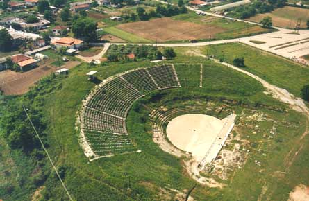
The sites of Almopia listed in the ancient sources were: Orma, Europos, and Apsalos

Orma

was listed as a site of Almopia only by Ptolemy (III, 13.24). Delacoulonche suggested that its name derived from the Greek word «orme» (=rush) and referred to the rush of the torrent that flowed through it and Demetsas located it at modern Orma (=ex. Tresino)
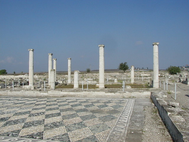
Europos

was as well mentioned by Ptolemy (III, 13.24) and Pliny ( IV, 35). Pliny located it near the river Loudias or Rhoedias, since it changed its name at this district. However, this single literary evidence combined with the absence of secure archaeological evidence led to a debate (Hammond, Demitsas, Dezert e.t.c.), as regards the place, that Europus had occupied.

Apsalos

was also recorded in Ptolemy' (III, 13.24) account of Almopian sites. Chrisostomou that its name meant a place that was adjacent to water. The only archaeological finds of the area were traces of fortifications to the south of the village modern Apsalso, some surface finds from the broader area of Apsalos and early-Christian buildings.

Sources

  • Demitsas M, Ancient Geography of Macedonia,1879
  • Nicholas Hammond, History of Macedonia Vol 1, 1972, Greek edition (1996)
  • Sakellariou, Macedonia: 4000 Years of Greek History, 1982
  • Nikolaos Martis, the Falsification of Macedonian History, 1984
  • Eugene Borza, the Shadow of Olympus,1993
  • Maria Girtzi, Historical topography of ancient Macedonia,2001

Eastern Macedonia, Mygdonia


General Information:
Herodotus description (VII, 123-127) of Xerxes march through Mygdonia constitutes the most ancient reference of the name of this district. Unfortunately the mythological record of Mygdonia remains scanty. As regards the name of this region, it was suggested that it derived from:
  • Mygdon, son of Ares and Kalliope, brother of Edonos, Odomantos and Biston, and father of Krousis and Grastos (Apollodorus B', 519)
  • a compound word consisting of «Mu» (=the letter that in the Phoenician alphabet stood for water) + «chthon» (=land), referring thus to the geophysical picture of the area
  • Mygdones, the local tribe.

Herodotus (VII, 124) also mentioned that Echedoros ran through Mygdonia, but it had its sources in Krestonia, implying thus that Krestonia lay to the north of Mygdonia. Consequently, the sources or the river Echedoros along with prolongations of Mts. Chortiates and Vertiscos formed the northern boundaries. Pliny (IV, 41), ignoring the existence of Bisaltia claimed that Mygdonia extended to the east as far as the river Strymon

According to the ancient sources and the archaeological theories, the initial inhabitants of this region were Pelasgians, since the Pelasgian kingdom extended as far as the Strymon (Aeschylus, Iketides, 253)] and Paiones as implied by Strabo's testimony (VII, fr.41) that Paionians occupied Mygdonia, once in the old time and then later and the theory of the habitation of Paionians to the area east of Axios from the end of Late Neolithic Era and on. Hammond (Macedonia:4000 years of Greek History, page 67) and Borza (page 75, the Shadow in Olympus) in the 6th century BC Paiones, as a result of the consequences of the Kimmerian migration re-entered Mygdonia and either pushed Mygdones to the east or ruled over them [ relying on Strabo's testimony (VII, fr.41) that Paionians occupied Mygdonia later as well and the discovery of Paionian coins in Lete (site of Mygdonia).

The annexation of Mygdonia -which serves as the starting point in the Macedonian history of this district- evidently took place in two phases. Namely, although Amyntas occupied the southwestern part of Mygdonia since he was able to offer Anthemous (lying to the southwest of Mygdonia) to Hippias (Herodotus V, 94), the eastern part remained independent (since Lete for instance issued coins bearing its own name till 480 BC)329. However, the rest of Mygdonia was incorporated by Alexander I after the Persian retreat. In an earlier period, Mygdonia, because of its key-position, had served as the camp of Xerxes' army and the main port of his navy (Herodotus VII, 124,127).

Mygdonia was secured as an integral part of the Macedonian Kingdom after Philip II's enthronement. Alexander the Great, in order to honour his Mygdonian army troop, gave the name of Mygdonia to a place in Mesopotamia (Pliny VI, 16). Moreover, Kassander in 315 BC, founded there Thessalonike, a very important site. During the struggles among the successors, Mygdonia was separated from L.M. districts only in 287/6 BC, when Pyrrhos and Lysimachos divided between them the Macedonian Kingdom (Pausanias I, 10.2).

Sites

The combination of the literary, historical and archaeological evidence led to the assumption that Mygdonia included at least the below mentioned sites: Therme, Thessalonike, Sindos, Chalastra, Lete, Apollonia, Arethousa, Bormiskos, Kalindoia, Xylopolis, Terpyllos, Karabia, Assiros, Antigoneia, Physka, Bairos, Bolbe, Altos, and Phileros.

Sources

  • Demitsas M, Ancient Geography of Macedonia,1879
  • Nicholas Hammond, History of Macedonia Vol 1, 1972, Greek edition (1996)
  • Sakellariou, Macedonia: 4000 Years of Greek History, 1982
  • Nikolaos Martis, the Falsification of Macedonian History
  • Maria Girtzi, Historical topography of ancient Macedonia,2001